Introduction to cf_xarray
This notebook is a brief introduction to cf_xarray’s current capabilities.
import numpy as np
import xarray as xr

import cf_xarray as cfxr

# For this notebooks, it's nicer if we don't show the array values by default
xr.set_options(display_expand_data=False)
<xarray.core.options.set_options at 0x7e12c419ddd0>
cf_xarray works best when xarray keeps attributes by default.
xr.set_options(keep_attrs=True)
<xarray.core.options.set_options at 0x7e1298b9c890>
Lets read two datasets.
ds = xr.tutorial.load_dataset("air_temperature")
ds.air.attrs["standard_name"] = "air_temperature"
ds
<xarray.Dataset> Size: 31MB
Dimensions:  (time: 2920, lat: 25, lon: 53)
Coordinates:
  * lat      (lat) float32 100B 75.0 72.5 70.0 67.5 65.0 ... 22.5 20.0 17.5 15.0
  * lon      (lon) float32 212B 200.0 202.5 205.0 207.5 ... 325.0 327.5 330.0
  * time     (time) datetime64[ns] 23kB 2013-01-01 ... 2014-12-31T18:00:00
Data variables:
    air      (time, lat, lon) float64 31MB 241.2 242.5 243.5 ... 296.2 295.7
Attributes:
    Conventions:  COARDS
    title:        4x daily NMC reanalysis (1948)
    description:  Data is from NMC initialized reanalysis\n(4x/day).  These a...
    platform:     Model
references: http://www.esrl.noaa.gov/psd/data/gridded/data.ncep.reanaly...This one is inspired by POP model output and illustrates how the coordinates
attribute is interpreted. It also illustrates one way of tagging curvilinear
grids for convenient use of cf_xarray
from cf_xarray.datasets import popds as pop

pop
<xarray.Dataset> Size: 29kB
Dimensions:  (nlat: 20, nlon: 30)
Coordinates:
    TLONG    (nlat, nlon) float64 5kB 1.0 1.0 1.0 1.0 1.0 ... 1.0 1.0 1.0 1.0
    TLAT     (nlat, nlon) float64 5kB 2.0 2.0 2.0 2.0 2.0 ... 2.0 2.0 2.0 2.0
    ULONG    (nlat, nlon) float64 5kB 0.5 0.5 0.5 0.5 0.5 ... 0.5 0.5 0.5 0.5
    ULAT     (nlat, nlon) float64 5kB 2.5 2.5 2.5 2.5 2.5 ... 2.5 2.5 2.5 2.5
  * nlon     (nlon) int64 240B 0 1 2 3 4 5 6 7 8 ... 21 22 23 24 25 26 27 28 29
  * nlat     (nlat) int64 160B 0 1 2 3 4 5 6 7 8 9 10 11 12 13 14 15 16 17 18 19
Data variables:
    UVEL     (nlat, nlon) float64 5kB 15.0 15.0 15.0 15.0 ... 15.0 15.0 15.0
TEMP (nlat, nlon) float64 5kB 15.0 15.0 15.0 15.0 ... 15.0 15.0 15.0This synthetic dataset has multiple X and Y coords. An example would be
model output on a staggered grid.
from cf_xarray.datasets import multiple

multiple
<xarray.Dataset> Size: 6kB
Dimensions:  (x1: 30, y1: 20, x2: 10, y2: 5)
Coordinates:
  * x1       (x1) int64 240B 0 1 2 3 4 5 6 7 8 9 ... 21 22 23 24 25 26 27 28 29
  * y1       (y1) int64 160B 0 1 2 3 4 5 6 7 8 9 10 11 12 13 14 15 16 17 18 19
  * x2       (x2) int64 80B 0 1 2 3 4 5 6 7 8 9
  * y2       (y2) int64 40B 0 1 2 3 4
Data variables:
    v1       (x1, y1) float64 5kB 15.0 15.0 15.0 15.0 ... 15.0 15.0 15.0 15.0
v2 (x2, y2) float64 400B 15.0 15.0 15.0 15.0 ... 15.0 15.0 15.0 15.0This dataset has ancillary variables
from cf_xarray.datasets import anc

anc
<xarray.Dataset> Size: 3kB
Dimensions:            (x: 10, y: 20)
Dimensions without coordinates: x, y
Data variables:
    q                  (x, y) float64 2kB 0.9349 0.5695 -0.6966 ... -0.3362 2.3
    q_error_limit      (x, y) float64 2kB -0.2564 1.19 -1.402 ... 0.4818 -1.768
q_detection_limit float64 8B 0.001What attributes have been discovered?
The criteria for identifying variables using CF attributes are listed here.
ds.lon
<xarray.DataArray 'lon' (lon: 53)> Size: 212B
200.0 202.5 205.0 207.5 210.0 212.5 ... 317.5 320.0 322.5 325.0 327.5 330.0
Coordinates:
  * lon      (lon) float32 212B 200.0 202.5 205.0 207.5 ... 325.0 327.5 330.0
Attributes:
    standard_name:  longitude
    long_name:      Longitude
    units:          degrees_east
axis: Xds.lon has attributes axis: X. This means that cf_xarray can identify the
'X' axis as being represented by the lon variable.
It can also use the standard_name and units attributes to infer that lon
is “Longitude”. To see variable names that cf_xarray can infer, use ds.cf
ds.cf
Coordinates:
             CF Axes: * X: ['lon']
                      * Y: ['lat']
                      * T: ['time']
                        Z: n/a

      CF Coordinates: * longitude: ['lon']
                      * latitude: ['lat']
                      * time: ['time']
                        vertical: n/a

       Cell Measures:   area, volume: n/a

      Standard Names: * latitude: ['lat']
                      * longitude: ['lon']
                      * time: ['time']

              Bounds:   n/a

       Grid Mappings:   n/a

Data Variables:
       Cell Measures:   area, volume: n/a

      Standard Names:   air_temperature: ['air']

              Bounds:   n/a

       Grid Mappings:   n/a
For pop, only latitude and longitude are detected, not X or Y. Please
comment here: https://github.com/xarray-contrib/cf-xarray/issues/23 if you have
opinions about this behaviour.
pop.cf
Coordinates:
             CF Axes: * X: ['nlon']
                      * Y: ['nlat']
                        Z, T: n/a

      CF Coordinates:   longitude: ['TLONG', 'ULONG']
                        latitude: ['TLAT', 'ULAT']
                        vertical, time: n/a

       Cell Measures:   area, volume: n/a

      Standard Names:   n/a

              Bounds:   n/a

       Grid Mappings:   n/a

Data Variables:
       Cell Measures:   area, volume: n/a

      Standard Names:   sea_water_potential_temperature: ['TEMP']
                        sea_water_x_velocity: ['UVEL']

              Bounds:   n/a

       Grid Mappings:   n/a
For multiple, multiple X and Y coordinates are detected
multiple.cf
Coordinates:
             CF Axes: * X: ['x1', 'x2']
                      * Y: ['y1', 'y2']
                        Z, T: n/a

      CF Coordinates:   longitude, latitude, vertical, time: n/a

       Cell Measures:   area, volume: n/a

      Standard Names:   n/a

              Bounds:   n/a

       Grid Mappings:   n/a

Data Variables:
       Cell Measures:   area, volume: n/a

      Standard Names:   n/a

              Bounds:   n/a

       Grid Mappings:   n/a
Feature: Accessing coordinate variables
.cf implements __getitem__ to allow easy access to coordinate and axis
variables.
ds.cf["X"]
<xarray.DataArray 'lon' (lon: 53)> Size: 212B
200.0 202.5 205.0 207.5 210.0 212.5 ... 317.5 320.0 322.5 325.0 327.5 330.0
Coordinates:
  * lon      (lon) float32 212B 200.0 202.5 205.0 207.5 ... 325.0 327.5 330.0
Attributes:
    standard_name:  longitude
    long_name:      Longitude
    units:          degrees_east
axis: XIndexing with a scalar key raises an error if the key maps to multiple variables names
multiple.cf["X"]
---------------------------------------------------------------------------
KeyError                                  Traceback (most recent call last)
Cell In[12], line 1
----> 1 multiple.cf["X"]

File ~/checkouts/readthedocs.org/user_builds/cf-xarray/checkouts/stable/cf_xarray/accessor.py:2838, in CFDatasetAccessor.__getitem__(self, key)
   2806 def __getitem__(self, key: Hashable | Iterable[Hashable]) -> DataArray | Dataset:
   2807     """
   2808     Index into a Dataset making use of CF attributes.
   2809
   (...)   2836     Add additional keys by specifying "custom criteria". See :ref:`custom_criteria` for more.
   2837     """
-> 2838     return _getitem(self, key)

File ~/checkouts/readthedocs.org/user_builds/cf-xarray/checkouts/stable/cf_xarray/accessor.py:1215, in _getitem(accessor, key, skip)
   1213 names = _get_all(obj, k)
   1214 names = drop_bounds(names)
-> 1215 check_results(names, k)
   1216 successful[k] = bool(names)
   1217 coords.extend(names)

File ~/checkouts/readthedocs.org/user_builds/cf-xarray/checkouts/stable/cf_xarray/accessor.py:1155, in _getitem.<locals>.check_results(names, key)
   1153 def check_results(names, key):
   1154     if scalar_key and len(names) > 1:
-> 1155         raise KeyError(
   1156             f"Receive multiple variables for key {key!r}: {names}. "
   1157             f"Expected only one. Please pass a list [{key!r}] "
   1158             f"instead to get all variables matching {key!r}."
   1159         )

KeyError: "Receive multiple variables for key 'X': {'x2', 'x1'}. Expected only one. Please pass a list ['X'] instead to get all variables matching 'X'."
pop.cf["longitude"]
---------------------------------------------------------------------------
KeyError                                  Traceback (most recent call last)
Cell In[13], line 1
----> 1 pop.cf["longitude"]

File ~/checkouts/readthedocs.org/user_builds/cf-xarray/checkouts/stable/cf_xarray/accessor.py:2838, in CFDatasetAccessor.__getitem__(self, key)
   2806 def __getitem__(self, key: Hashable | Iterable[Hashable]) -> DataArray | Dataset:
   2807     """
   2808     Index into a Dataset making use of CF attributes.
   2809
   (...)   2836     Add additional keys by specifying "custom criteria". See :ref:`custom_criteria` for more.
   2837     """
-> 2838     return _getitem(self, key)

File ~/checkouts/readthedocs.org/user_builds/cf-xarray/checkouts/stable/cf_xarray/accessor.py:1215, in _getitem(accessor, key, skip)
   1213 names = _get_all(obj, k)
   1214 names = drop_bounds(names)
-> 1215 check_results(names, k)
   1216 successful[k] = bool(names)
   1217 coords.extend(names)

File ~/checkouts/readthedocs.org/user_builds/cf-xarray/checkouts/stable/cf_xarray/accessor.py:1155, in _getitem.<locals>.check_results(names, key)
   1153 def check_results(names, key):
   1154     if scalar_key and len(names) > 1:
-> 1155         raise KeyError(
   1156             f"Receive multiple variables for key {key!r}: {names}. "
   1157             f"Expected only one. Please pass a list [{key!r}] "
   1158             f"instead to get all variables matching {key!r}."
   1159         )

KeyError: "Receive multiple variables for key 'longitude': {'ULONG', 'TLONG'}. Expected only one. Please pass a list ['longitude'] instead to get all variables matching 'longitude'."
To get back all variables associated with that key, pass a single element list instead.
multiple.cf[["X"]]
<xarray.Dataset> Size: 320B
Dimensions:  (x2: 10, x1: 30)
Coordinates:
  * x2       (x2) int64 80B 0 1 2 3 4 5 6 7 8 9
  * x1       (x1) int64 240B 0 1 2 3 4 5 6 7 8 9 ... 21 22 23 24 25 26 27 28 29
Data variables:
*empty*pop.cf[["longitude"]]
<xarray.Dataset> Size: 10kB
Dimensions:  (nlat: 20, nlon: 30)
Coordinates:
    ULONG    (nlat, nlon) float64 5kB 0.5 0.5 0.5 0.5 0.5 ... 0.5 0.5 0.5 0.5
    TLONG    (nlat, nlon) float64 5kB 1.0 1.0 1.0 1.0 1.0 ... 1.0 1.0 1.0 1.0
  * nlon     (nlon) int64 240B 0 1 2 3 4 5 6 7 8 ... 21 22 23 24 25 26 27 28 29
  * nlat     (nlat) int64 160B 0 1 2 3 4 5 6 7 8 9 10 11 12 13 14 15 16 17 18 19
Data variables:
*empty*DataArrays return DataArrays
pop.UVEL.cf["longitude"]
<xarray.DataArray 'ULONG' (nlat: 20, nlon: 30)> Size: 5kB
0.5 0.5 0.5 0.5 0.5 0.5 0.5 0.5 0.5 0.5 ... 0.5 0.5 0.5 0.5 0.5 0.5 0.5 0.5 0.5
Coordinates:
  * nlon     (nlon) int64 240B 0 1 2 3 4 5 6 7 8 ... 21 22 23 24 25 26 27 28 29
  * nlat     (nlat) int64 160B 0 1 2 3 4 5 6 7 8 9 10 11 12 13 14 15 16 17 18 19
Attributes:
units: degrees_eastDataset.cf[...] returns a single DataArray, parsing the coordinates
attribute if present, so we correctly get the TLONG variable and not the
ULONG variable
pop.cf["TEMP"]
<xarray.DataArray 'TEMP' (nlat: 20, nlon: 30)> Size: 5kB
15.0 15.0 15.0 15.0 15.0 15.0 15.0 15.0 ... 15.0 15.0 15.0 15.0 15.0 15.0 15.0
Coordinates:
  * nlon     (nlon) int64 240B 0 1 2 3 4 5 6 7 8 ... 21 22 23 24 25 26 27 28 29
  * nlat     (nlat) int64 160B 0 1 2 3 4 5 6 7 8 9 10 11 12 13 14 15 16 17 18 19
    TLONG    (nlat, nlon) float64 5kB 1.0 1.0 1.0 1.0 1.0 ... 1.0 1.0 1.0 1.0
    TLAT     (nlat, nlon) float64 5kB 2.0 2.0 2.0 2.0 2.0 ... 2.0 2.0 2.0 2.0
Attributes:
    coordinates:    TLONG TLAT
standard_name: sea_water_potential_temperatureDataset.cf[...] also interprets the ancillary_variables attribute. The
ancillary variables are returned as coordinates of a DataArray
anc.cf["q"]
<xarray.DataArray 'q' (x: 10, y: 20)> Size: 2kB
0.9349 0.5695 -0.6966 -1.336 0.2412 0.2206 ... -1.545 -1.501 -1.287 -0.3362 2.3
Coordinates:
    q_error_limit      (x, y) float64 2kB -0.2564 1.19 -1.402 ... 0.4818 -1.768
    q_detection_limit  float64 8B 0.001
Dimensions without coordinates: x, y
Attributes:
    standard_name:        specific_humidity
    units:                g/g
ancillary_variables: q_error_limit q_detection_limitFeature: Accessing variables by standard names
pop.cf[["sea_water_potential_temperature", "UVEL"]]
<xarray.Dataset> Size: 29kB
Dimensions:  (nlat: 20, nlon: 30)
Coordinates:
    TLONG    (nlat, nlon) float64 5kB 1.0 1.0 1.0 1.0 1.0 ... 1.0 1.0 1.0 1.0
    TLAT     (nlat, nlon) float64 5kB 2.0 2.0 2.0 2.0 2.0 ... 2.0 2.0 2.0 2.0
    ULONG    (nlat, nlon) float64 5kB 0.5 0.5 0.5 0.5 0.5 ... 0.5 0.5 0.5 0.5
    ULAT     (nlat, nlon) float64 5kB 2.5 2.5 2.5 2.5 2.5 ... 2.5 2.5 2.5 2.5
  * nlon     (nlon) int64 240B 0 1 2 3 4 5 6 7 8 ... 21 22 23 24 25 26 27 28 29
  * nlat     (nlat) int64 160B 0 1 2 3 4 5 6 7 8 9 10 11 12 13 14 15 16 17 18 19
Data variables:
    TEMP     (nlat, nlon) float64 5kB 15.0 15.0 15.0 15.0 ... 15.0 15.0 15.0
UVEL (nlat, nlon) float64 5kB 15.0 15.0 15.0 15.0 ... 15.0 15.0 15.0Note that ancillary variables are included as coordinate variables
anc.cf["specific_humidity"]
<xarray.DataArray 'q' (x: 10, y: 20)> Size: 2kB
0.9349 0.5695 -0.6966 -1.336 0.2412 0.2206 ... -1.545 -1.501 -1.287 -0.3362 2.3
Coordinates:
    q_error_limit      (x, y) float64 2kB -0.2564 1.19 -1.402 ... 0.4818 -1.768
    q_detection_limit  float64 8B 0.001
Dimensions without coordinates: x, y
Attributes:
    standard_name:        specific_humidity
    units:                g/g
ancillary_variables: q_error_limit q_detection_limitFeature: Utility functions
There are some utility functions to allow use by downstream libraries
pop.cf.keys()
{'X',
 'Y',
 'latitude',
 'longitude',
 'sea_water_potential_temperature',
 'sea_water_x_velocity'}
You can test for presence of these keys
"sea_water_x_velocity" in pop.cf
True
You can also get out the available Axis names
pop.cf.axes
{'X': ['nlon'], 'Y': ['nlat']}
or available Coordinate names. Same for cell measures (.cf.cell_measures) and
standard names (.cf.standard_names).
pop.cf.coordinates
{'longitude': ['TLONG', 'ULONG'], 'latitude': ['TLAT', 'ULAT']}
Note: Although it is possible to assign additional coordinates,
.cf.coordinates only returns a subset of
("longitude", "latitude", "vertical", "time").
Feature: Rewriting property dictionaries
cf_xarray will rewrite the .sizes and .chunks dictionaries so that one can
index by a special CF axis or coordinate name
ds.cf.sizes
{'time': 2920, 'T': 2920, 'latitude': 25, 'Y': 25, 'longitude': 53, 'X': 53}
Note the duplicate entries above:
One for
X,Y,Tand one for
longitude,latitudeandtime.
An error is raised if there are multiple 'X' variables (for example)
multiple.cf.sizes
---------------------------------------------------------------------------
AttributeError                            Traceback (most recent call last)
Cell In[26], line 1
----> 1 multiple.cf.sizes

File ~/checkouts/readthedocs.org/user_builds/cf-xarray/checkouts/stable/cf_xarray/accessor.py:1931, in CFAccessor.__getattr__(self, attr)
   1930 def __getattr__(self, attr):
-> 1931     return _getattr(
   1932         obj=self._obj,
   1933         attr=attr,
   1934         accessor=self,
   1935         key_mappers=_DEFAULT_KEY_MAPPERS,
   1936         wrap_classes=True,
   1937     )

File ~/checkouts/readthedocs.org/user_builds/cf-xarray/checkouts/stable/cf_xarray/accessor.py:1039, in _getattr(obj, attr, accessor, key_mappers, wrap_classes, extra_decorator)
   1037     for name in inverted[key]:
   1038         if name in newmap:
-> 1039             raise AttributeError(
   1040                 f"cf_xarray can't wrap attribute {attr!r} because there are multiple values for {name!r}. "
   1041                 f"There is no unique mapping from {name!r} to a value in {attr!r}."
   1042             )
   1043     newmap.update(dict.fromkeys(inverted[key], value))
   1044 newmap.update({key: attribute[key] for key in unused_keys})

AttributeError: cf_xarray can't wrap attribute 'sizes' because there are multiple values for 'X'. There is no unique mapping from 'X' to a value in 'sizes'.
multiple.v1.cf.sizes
{'X': 30, 'Y': 20}
Feature: Renaming variables
cf_xarray lets you rewrite variables in one dataset to like variables in
another dataset.
In this example, a one-to-one mapping is not possible and the coordinate variables are not renamed.
da = pop.cf["TEMP"]
da.cf.rename_like(ds)
/tmp/ipykernel_1590/2327264871.py:2: UserWarning: Conflicting variables skipped:
['TLAT']: ['lat'] (latitude)
['TLONG']: ['lon'] (longitude)
['nlat']: ['lat'] (Y)
['nlon']: ['lon'] (X)
  da.cf.rename_like(ds)
<xarray.DataArray 'TEMP' (nlat: 20, nlon: 30)> Size: 5kB
15.0 15.0 15.0 15.0 15.0 15.0 15.0 15.0 ... 15.0 15.0 15.0 15.0 15.0 15.0 15.0
Coordinates:
  * nlon     (nlon) int64 240B 0 1 2 3 4 5 6 7 8 ... 21 22 23 24 25 26 27 28 29
  * nlat     (nlat) int64 160B 0 1 2 3 4 5 6 7 8 9 10 11 12 13 14 15 16 17 18 19
    TLONG    (nlat, nlon) float64 5kB 1.0 1.0 1.0 1.0 1.0 ... 1.0 1.0 1.0 1.0
    TLAT     (nlat, nlon) float64 5kB 2.0 2.0 2.0 2.0 2.0 ... 2.0 2.0 2.0 2.0
Attributes:
    coordinates:    TLONG TLAT
standard_name: sea_water_potential_temperatureIf we exclude all axes (variables with axis attribute), a one-to-one mapping
is possible. In this example, TLONG and TLAT are renamed to lon and lat
i.e. their counterparts in ds. Note the the coordinates attribute is
appropriately changed.
da.cf.rename_like(ds, skip="axes")
<xarray.DataArray 'TEMP' (nlat: 20, nlon: 30)> Size: 5kB
15.0 15.0 15.0 15.0 15.0 15.0 15.0 15.0 ... 15.0 15.0 15.0 15.0 15.0 15.0 15.0
Coordinates:
  * nlon     (nlon) int64 240B 0 1 2 3 4 5 6 7 8 ... 21 22 23 24 25 26 27 28 29
  * nlat     (nlat) int64 160B 0 1 2 3 4 5 6 7 8 9 10 11 12 13 14 15 16 17 18 19
    lon      (nlat, nlon) float64 5kB 1.0 1.0 1.0 1.0 1.0 ... 1.0 1.0 1.0 1.0
    lat      (nlat, nlon) float64 5kB 2.0 2.0 2.0 2.0 2.0 ... 2.0 2.0 2.0 2.0
Attributes:
    coordinates:    lon lat
standard_name: sea_water_potential_temperatureFeature: Rewriting arguments
cf_xarray can rewrite arguments for a large number of xarray functions. By
this I mean that instead of specifying say dim="lon", you can pass dim="X"
or dim="longitude" and cf_xarray will rewrite that to dim="lon" based on
the attributes present in the dataset.
Here are a few examples
Slicing
ds.air.cf.isel(T=1)
<xarray.DataArray 'air' (lat: 25, lon: 53)> Size: 11kB
242.1 242.7 243.1 243.4 243.6 243.8 ... 297.5 297.1 296.9 296.4 296.4 296.6
Coordinates:
  * lat      (lat) float32 100B 75.0 72.5 70.0 67.5 65.0 ... 22.5 20.0 17.5 15.0
  * lon      (lon) float32 212B 200.0 202.5 205.0 207.5 ... 325.0 327.5 330.0
    time     datetime64[ns] 8B 2013-01-01T06:00:00
Attributes:
    long_name:      4xDaily Air temperature at sigma level 995
    units:          degK
    precision:      2
    GRIB_id:        11
    GRIB_name:      TMP
    var_desc:       Air temperature
    dataset:        NMC Reanalysis
    level_desc:     Surface
    statistic:      Individual Obs
    parent_stat:    Other
    actual_range:   [185.16 322.1 ]
standard_name: air_temperatureSlicing works will expand a single key like X to multiple dimensions if those
dimensions are tagged with axis: X
multiple.cf.isel(X=1, Y=1)
<xarray.Dataset> Size: 48B
Dimensions:  ()
Coordinates:
    x1       int64 8B 1
    y1       int64 8B 1
    x2       int64 8B 1
    y2       int64 8B 1
Data variables:
    v1       float64 8B 15.0
v2 float64 8B 15.0Reductions
ds.air.cf.mean("X")
<xarray.DataArray 'air' (time: 2920, lat: 25)> Size: 584kB
242.0 242.0 243.7 251.2 257.2 260.8 ... 292.3 294.4 295.8 297.0 297.9 298.8
Coordinates:
  * lat      (lat) float32 100B 75.0 72.5 70.0 67.5 65.0 ... 22.5 20.0 17.5 15.0
  * time     (time) datetime64[ns] 23kB 2013-01-01 ... 2014-12-31T18:00:00
Attributes:
    long_name:      4xDaily Air temperature at sigma level 995
    units:          degK
    precision:      2
    GRIB_id:        11
    GRIB_name:      TMP
    var_desc:       Air temperature
    dataset:        NMC Reanalysis
    level_desc:     Surface
    statistic:      Individual Obs
    parent_stat:    Other
    actual_range:   [185.16 322.1 ]
standard_name: air_temperatureExpanding to multiple dimensions is also supported
# takes the mean along ["x1", "x2"]
multiple.cf.mean("X")
<xarray.Dataset> Size: 400B
Dimensions:  (y1: 20, y2: 5)
Coordinates:
  * y1       (y1) int64 160B 0 1 2 3 4 5 6 7 8 9 10 11 12 13 14 15 16 17 18 19
  * y2       (y2) int64 40B 0 1 2 3 4
Data variables:
    v1       (y1) float64 160B 15.0 15.0 15.0 15.0 15.0 ... 15.0 15.0 15.0 15.0
v2 (y2) float64 40B 15.0 15.0 15.0 15.0 15.0Plotting
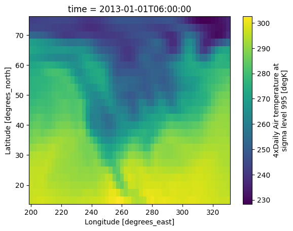
ds.air.cf.isel(time=1).cf.plot(x="X", y="Y")
<matplotlib.collections.QuadMesh at 0x7e1292e895d0>
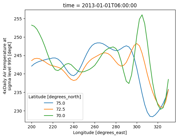
ds.air.cf.isel(T=1, Y=[0, 1, 2]).cf.plot(x="longitude", hue="latitude")
[<matplotlib.lines.Line2D at 0x7e129071a2d0>,
 <matplotlib.lines.Line2D at 0x7e12929decd0>,
 <matplotlib.lines.Line2D at 0x7e1292915b10>]
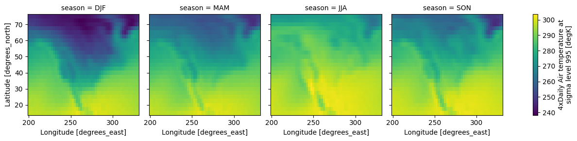
cf_xarray can facet
seasonal = (
    ds.air.groupby("time.season").mean().reindex(season=["DJF", "MAM", "JJA", "SON"])
)
seasonal.cf.plot(x="longitude", y="latitude", col="season")
<xarray.plot.facetgrid.FacetGrid at 0x7e12907eb950>
Resample & groupby
ds.cf.resample(T="D").mean()
<xarray.Dataset> Size: 8MB
Dimensions:  (time: 730, lat: 25, lon: 53)
Coordinates:
  * lat      (lat) float32 100B 75.0 72.5 70.0 67.5 65.0 ... 22.5 20.0 17.5 15.0
  * lon      (lon) float32 212B 200.0 202.5 205.0 207.5 ... 325.0 327.5 330.0
  * time     (time) datetime64[ns] 6kB 2013-01-01 2013-01-02 ... 2014-12-31
Data variables:
    air      (time, lat, lon) float64 8MB 241.9 242.3 242.7 ... 295.9 295.5
Attributes:
    Conventions:  COARDS
    title:        4x daily NMC reanalysis (1948)
    description:  Data is from NMC initialized reanalysis\n(4x/day).  These a...
    platform:     Model
references: http://www.esrl.noaa.gov/psd/data/gridded/data.ncep.reanaly...cf_xarray also understands the “datetime accessor” syntax for groupby
ds.cf.groupby("T.month").mean("longitude")
<xarray.Dataset> Size: 607kB
Dimensions:  (time: 2920, lat: 25)
Coordinates:
  * lat      (lat) float32 100B 75.0 72.5 70.0 67.5 65.0 ... 22.5 20.0 17.5 15.0
  * time     (time) datetime64[ns] 23kB 2013-01-01 ... 2014-12-31T18:00:00
Data variables:
    air      (time, lat) float64 584kB 242.0 242.0 243.7 ... 297.0 297.9 298.8
Attributes:
    Conventions:  COARDS
    title:        4x daily NMC reanalysis (1948)
    description:  Data is from NMC initialized reanalysis\n(4x/day).  These a...
    platform:     Model
references: http://www.esrl.noaa.gov/psd/data/gridded/data.ncep.reanaly...Rolling & coarsen
ds.cf.rolling(X=5).mean()
<xarray.Dataset> Size: 31MB
Dimensions:  (lat: 25, lon: 53, time: 2920)
Coordinates:
  * lat      (lat) float32 100B 75.0 72.5 70.0 67.5 65.0 ... 22.5 20.0 17.5 15.0
  * lon      (lon) float32 212B 200.0 202.5 205.0 207.5 ... 325.0 327.5 330.0
  * time     (time) datetime64[ns] 23kB 2013-01-01 ... 2014-12-31T18:00:00
Data variables:
    air      (time, lat, lon) float64 31MB nan nan nan nan ... 297.6 297.0 296.6
Attributes:
    Conventions:  COARDS
    title:        4x daily NMC reanalysis (1948)
    description:  Data is from NMC initialized reanalysis\n(4x/day).  These a...
    platform:     Model
references: http://www.esrl.noaa.gov/psd/data/gridded/data.ncep.reanaly...coarsen works but everything later will break because of xarray bug
https://github.com/pydata/xarray/issues/4120
ds.isel(lon=slice(50)).cf.coarsen(Y=5, X=10).mean()
Feature: mix “special names” and variable names
ds.cf.groupby("T.month").mean(["lat", "X"])
<xarray.Dataset> Size: 47kB
Dimensions:  (time: 2920)
Coordinates:
  * time     (time) datetime64[ns] 23kB 2013-01-01 ... 2014-12-31T18:00:00
Data variables:
    air      (time) float64 23kB 274.2 273.5 273.2 273.6 ... 273.0 273.0 273.4
Attributes:
    Conventions:  COARDS
    title:        4x daily NMC reanalysis (1948)
    description:  Data is from NMC initialized reanalysis\n(4x/day).  These a...
    platform:     Model
references: http://www.esrl.noaa.gov/psd/data/gridded/data.ncep.reanaly...Feature: Weight by Cell Measures
cf_xarray can weight by cell measure variables if the appropriate attribute is
set
# Lets make some weights (not sure if this is right)
ds.coords["cell_area"] = (
    np.cos(ds.air.cf["latitude"] * np.pi / 180)
    * xr.ones_like(ds.air.cf["longitude"])
    * 105e3
    * 110e3
)
# and set proper attributes
ds["cell_area"].attrs = dict(standard_name="cell_area", units="m2")
ds.air.attrs["cell_measures"] = "area: cell_area"
ds.air.cf.weighted("area").mean(["latitude", "time"]).cf.plot(x="longitude")
ds.air.mean(["lat", "time"]).cf.plot(x="longitude")
[<matplotlib.lines.Line2D at 0x7e128e9f1590>]

Feature: Cell boundaries and vertices
cf_xarray can infer cell boundaries (for rectilinear grids) and convert
CF-standard bounds variables to vertices.
ds_bnds = ds.cf.add_bounds(["lat", "lon"])
ds_bnds
<xarray.Dataset> Size: 31MB
Dimensions:     (time: 2920, lat: 25, lon: 53, bounds: 2)
Coordinates:
  * lat         (lat) float32 100B 75.0 72.5 70.0 67.5 ... 22.5 20.0 17.5 15.0
  * lon         (lon) float32 212B 200.0 202.5 205.0 207.5 ... 325.0 327.5 330.0
  * time        (time) datetime64[ns] 23kB 2013-01-01 ... 2014-12-31T18:00:00
    cell_area   (lat, lon) float32 5kB 2.989e+09 2.989e+09 ... 1.116e+10
    lat_bounds  (lat, bounds) float32 200B 76.25 73.75 73.75 ... 16.25 13.75
    lon_bounds  (lon, bounds) float32 424B 198.8 201.2 201.2 ... 328.8 331.2
Dimensions without coordinates: bounds
Data variables:
    air         (time, lat, lon) float64 31MB 241.2 242.5 243.5 ... 296.2 295.7
Attributes:
    Conventions:  COARDS
    title:        4x daily NMC reanalysis (1948)
    description:  Data is from NMC initialized reanalysis\n(4x/day).  These a...
    platform:     Model
references: http://www.esrl.noaa.gov/psd/data/gridded/data.ncep.reanaly...We can also convert each bounds variable independently with the top-level functions
lat_bounds = ds_bnds.cf.get_bounds("latitude")

lat_vertices = cfxr.bounds_to_vertices(lat_bounds, bounds_dim="bounds")
lat_vertices
<xarray.DataArray 'lat_bounds' (lat_vertices: 26)> Size: 104B
76.25 73.75 71.25 68.75 66.25 63.75 ... 26.25 23.75 21.25 18.75 16.25 13.75
Dimensions without coordinates: lat_vertices
# Or we can convert _all_ bounds variables on a dataset
ds_crns = ds_bnds.cf.bounds_to_vertices()
ds_crns
<xarray.Dataset> Size: 31MB
Dimensions:       (time: 2920, lat: 25, lon: 53, bounds: 2, lat_vertices: 26,
                   lon_vertices: 54)
Coordinates:
  * lat           (lat) float32 100B 75.0 72.5 70.0 67.5 ... 22.5 20.0 17.5 15.0
  * lon           (lon) float32 212B 200.0 202.5 205.0 ... 325.0 327.5 330.0
  * time          (time) datetime64[ns] 23kB 2013-01-01 ... 2014-12-31T18:00:00
    cell_area     (lat, lon) float32 5kB 2.989e+09 2.989e+09 ... 1.116e+10
    lat_bounds    (lat, bounds) float32 200B 76.25 73.75 73.75 ... 16.25 13.75
    lon_bounds    (lon, bounds) float32 424B 198.8 201.2 201.2 ... 328.8 331.2
  * lat_vertices  (lat_vertices) float32 104B 76.25 73.75 71.25 ... 16.25 13.75
  * lon_vertices  (lon_vertices) float32 216B 198.8 201.2 203.8 ... 328.8 331.2
Dimensions without coordinates: bounds
Data variables:
    air           (time, lat, lon) float64 31MB 241.2 242.5 ... 296.2 295.7
Attributes:
    Conventions:  COARDS
    title:        4x daily NMC reanalysis (1948)
    description:  Data is from NMC initialized reanalysis\n(4x/day).  These a...
    platform:     Model
references: http://www.esrl.noaa.gov/psd/data/gridded/data.ncep.reanaly...Feature: Add canonical CF attributes
cf_xarray can add missing canonical CF attributes consistent with the official
CF standard name table.
ds_canonical = ds.cf.add_canonical_attributes(verbose=True)
ds_canonical
CF Standard Name Table info:
- version_number: 94
- conventions: CF-StandardNameTable-94
- first_published: 2026-06-09T17:23:36Z
- last_modified: 2026-06-09T17:23:36Z
- institution: Centre for Environmental Data Analysis
- contact: support@ceda.ac.uk

Attributes added:
- air:
    * description: Air temperature is the bulk temperature of the air, not the surface (skin) temperature. It is strongly recommended that a variable with this standard name should have a units_metadata attribute, with one of the values "on-scale" or "difference", whichever is appropriate for the data, because it is essential to know whether the temperature is on-scale (meaning relative to the origin of the scale indicated by the units) or refers to temperature differences (implying that the origin of the temperature scale is irrevelant), in order to convert the units correctly (cf. https://cfconventions.org/cf-conventions/cf-conventions.html#temperature-units).

- lat:
    * description: Latitude is positive northward; its units of degree_north (or equivalent) indicate this explicitly. In a latitude-longitude system defined with respect to a rotated North Pole, the standard name of grid_latitude should be used instead of latitude. Grid latitude is positive in the grid-northward direction, but its units should be plain degree.

- lon:
    * description: Longitude is positive eastward; its units of degree_east (or equivalent) indicate this explicitly. In a latitude-longitude system defined with respect to a rotated North Pole, the standard name of grid_longitude should be used instead of longitude. Grid longitude is positive in the grid-eastward direction, but its units should be plain degree.

- cell_area:
    * description: "Cell_area" is the horizontal area of a gridcell.
<xarray.Dataset> Size: 31MB
Dimensions:    (time: 2920, lat: 25, lon: 53)
Coordinates:
  * lat        (lat) float32 100B 75.0 72.5 70.0 67.5 ... 22.5 20.0 17.5 15.0
  * lon        (lon) float32 212B 200.0 202.5 205.0 207.5 ... 325.0 327.5 330.0
  * time       (time) datetime64[ns] 23kB 2013-01-01 ... 2014-12-31T18:00:00
    cell_area  (lat, lon) float32 5kB 2.989e+09 2.989e+09 ... 1.116e+10
Data variables:
    air        (time, lat, lon) float64 31MB 241.2 242.5 243.5 ... 296.2 295.7
Attributes:
    Conventions:  COARDS
    title:        4x daily NMC reanalysis (1948)
    description:  Data is from NMC initialized reanalysis\n(4x/day).  These a...
    platform:     Model
    references:   http://www.esrl.noaa.gov/psd/data/gridded/data.ncep.reanaly...
    history:      Fri Jun 12 18:21:17 2026: cf.add_canonical_attributes(overr...